Settle - Carlisle railway line
The railway is England's most spectacular main line railway, built to as the a key link connecting Leeds to Carlisle for the Midland Railway's express service between London and Scotland. It is a superb example of Victorian engineering achievement, driven through the most hostile but beautiful terrain.
History
The line was built between 1869 and 1876, at the height of 19th century rail expansion. It was born out of inter-company rivalry, and it required superb engineering to provide a high speed route through such difficult terrain. It doesn't wind slowly around the hills but cuts boldly through them. The engineers skillfully exploited the terrain using cuttings and tunnels, with the line skirting the sides of hills, to achieve a high speed route with no curves less than 1000 yards radius, and no gradient more than 1 in 100.
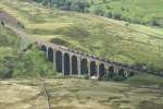
I first became aware of the line when we walked the Pennine Way in 1970. We sat eating our lunch at Cam End, an ancient junction of Roman roads several miles to the east of the line, and saw the vast span of Ribblehead Viaduct in the distance. Then in the early 1980s, when British Rail misguidedly tried to close the line, I joined the Friends of the Settle Carlisle Line to help save it. The closure battle was long and controversial. It produced over 32,000 objections, the largest public reaction to any rail closure proposal ever. I spoke at one of the closure hearings in Carlisle, having of course travelled there via the line. Eventually, in 1989 the line was reprieved. Paradoxically, its usage had already dramatically increased under the talented influence of its local management led by Ron Cotton.
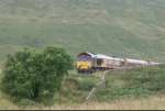
Since then, much of the infrastructure has been upgraded, and new services introduced. As well as much expanded passenger traffic (local commuters as well as tourists) the line became heavily used by goods traffic. Southbound the main flow was imported coal from the Ayrshire ports to the Yorkshire power stations, with a strong reverse flow of gypsum from the gas desulphurisation plants at the power stations to plasterboard works near the north of the line. That traffic reduced with the reduction in coal use for electricity generation but new traffic has been created. This includes timber for processing in Wales and stone from the newly rail connected quarries near Horton in Ribblesdale.
The line also acted as a diversionary route on the regular occasions when the heavily used main line over Shap Fell was closed for maintenance, but this use also reduced as the privatised rail companies found it easier to force passengers onto replacement busses than to organise the diversion of trains via other routes.
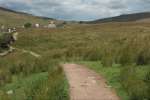
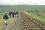
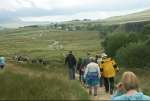
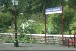
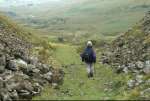
The line is also popular with walkers using the line to access the dales, with the ability to walk between stations offering more choice than having to return to the same spot. It is heavily used by tourists, as part of wider tours or as the central feature. Many tours use the local services but excursion companies often run excursions, either hauled by steam or heritage diesel locomotives. – hardly surprising, given the stunning sceneray. See old pictures (1976-1989).
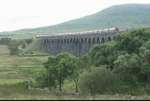
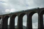
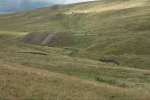
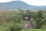
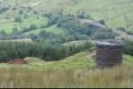
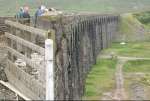
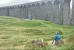
If you have never visited the line, then you should do so. It is an experience not to be missed. And don't just ride from end to end. Alight at stations along the route to enjoy the surrounding countryside. Or walk from one station to another. Walks between two points can be much more satisfying than the same distance walked in a circle back to where you started and you can usually see more along the way. Some of the line's structures look even more spectacular when viewed from the landscape than when viewed from the train (see pictures below). Each summer the Friends of the Settle-Carlisle Line organise guided walks from the stations to places of interest.
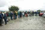
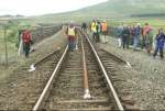
In July 2007 when the line was closed for engineering work, the Friends arranged for 2200 members of the public to walk across Ribblehead Viaduct, before the line re-opened. Some pictures from this event are included below. A similar event a couple of years later was also heavily subscribed. Both these events were by-products of the major refurbishment of the track and structures.
In 2012 a team began documenting all the structures along the line and their history, as an online historical record with many pictures over the years, see the SCRCA web portal .
See also my talk on the Settle-Carlisle line , the story of my Ribblehead Viaduct sweater , ny journey from Carlisle to Settle by rail (in snow), and walking Carlisle to Settle on foot.
The Settle-Carlisle line is just one example of where short sighted considerations closed (or in this case nearly closed) a railway with great potential. There are many other lines that were closed, but need re-opening in order to provide a more effective rail network. Many lines have been opened in the last few decades, often performing far in excess of their predicted passenger numbers. Many more need to be opened: lines that form a 'missing link', lines needed to increase capacity on strategic routes, lines that can provide diversionary routes when a line is closed for engineering work or any other reason. These are just a few of the ways that the UK's rail network needs developing to meet modern needs and future challenges. Sadly, the 'powers that be' cannot always be relied on to do the right thing, which is why campaigning organisations like RailFuture exist to help promote the development of rail as part of a sustainable transport service.
Copyright © 2005 - 2019 John Harrison
Links
Friends of the Settle-Carlisle Line (FoSCL) – The largest rail user support group. See: website
Settle-Carlisle Railway Development Company Ltd – Encourages ststainable development along the line. See: website
Settle-Carlisle Railway Trust – Helps to preserve, restore and maintain historic structures along the line. See: website
Settle-Carlisle Railway Conservation Area – Area of special architectural and historical interest, being documented pictorially online. See: website
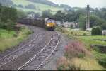
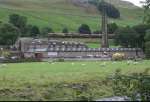
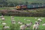
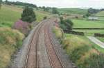
Pictures
See all pictures together , or click on each to enlarge and use arrows to move between them.
See also: Old pictures (1976-1989). Pictures Copyright © 2004 - 2015 John Harrison.